 One of the primary objects of land surveying is to determine the area of the land surveyed. Areas may be determined by: 1. computation from field notes: It can be done by two ways.
Calculation of the area of the skeleton of the survey and
Calculation of the area enclosed between survey lines of skeleton and boundaries.
a. Areas of skeleton:
BY geometry
Co-ordinates
By Geometry:
Area of triangle forming skeleton
Area = under route s(s-a) (s-b) (s-c)Where a, b, c, are the side of triangle and semi perimeter, s=a+b+c/2
Area = ½ x base x height
Area of rectangle = length x width
Area of square = side2
Area of Trapezium = ½ (sum of parallel sides) x distance between them
= ½ (a + b) x h
Computation of Area from Previously Plotted Plan:
The area may be calculated in the following two ways:
Case 1 – Graphical method
Case 2 – Instrumental Method
Case 1- Graphical Method:
The graphical methods are those in which the required data obtained from measurements of plan.In this case the area of figure is found as a whole, or the areas of the skeleton and the irregular strips are found separately.
A. Considering Entire Areas:
By division into triangles:
The most convenient method is to divide the figure in to a number of triangles. The base and altitude of each triangle are scaled and its area is found.
By division into square:
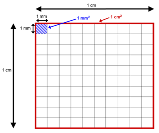
In this method a peace of tracing paper ruled out into squares, each responding a definite number of square meter or square centimeter is placed over the drawing. The number of whole square is measure and area is found. The portions of broken square are estimated in terms of Whole Square and broken squares.
By division into trapezoids or By drawing parallel lines and converting them to rectangle:
By placing the tracing paper over the plan the length the rectangles is obtained.
And area is calculated as:Required area = {length of rectangles} x {constant distance common breadth}
b. Considering the area along Boundaries:
The mid ordinate rule:
In this method the coordinates are measured at the mid- point of each division and the area is calculated by
Following Formula:
h1+h2+h3+……….. +hn
Area = ———————————– X 1
N
Or = (h1+h2+h3+ ………+hn) d Where,h1, h2, h3… = Ordinates at the mid points
1 = length of the base line.
n = number of equal parts in to which the base line is divided
d = common distance between the ordinates 1/n
2. The average ordinate rule:
(Oo +O1+O2 +…………+0n)
Area of strip = —————————————– X L
n + 1
3. Trapezoidal rule:
Area of strangle = d/2 (0o+201+202+…………20n-1+0n)
If we consider the boundary on both side of survey line ab, thenArea of triangle = d [(0o+0n)/2 + 01+02+…………. + 0n-1)
4. Simpson’s rule:
In this rule, the boundaries between the ends of coordinates are assumed an area of a parabolaSimpson’s rule is sometimes called parabolic rule.
Area= d/3(01+402+203+404+……………….0n)
= d/3 {01+0n+4(02+04+………..)+2(03+05+…………….)}Common distance = {1st ordinate + last ordinate)
+4(sum of even ordinates)
+2(sum of remaining odd ordinates)}
Case 2: Instrumental method:
This method consists of determining the area of a given map [figure] the uses of a planimeter.It is the best and most expeditious method and gives accurate results than other methods.
Calculation from the field notes:
There are two types of planimeter:
The Amsler polar planimeter and
The rolling planimeter.


